
[News] Space Shift Presents Research at International Conferences EUSAR 2026 and ESA FRINGE 2026
Space Shift, Inc. presented research results at two international conferences on Synthetic Aperture Radar (SAR) held in June 2026: EUSAR 2026 in Baden-Baden, Germany, and ESA FRINGE 2026 in Krakow, Poland.
1.Overview of EUSAR 2026
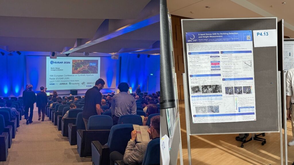
EUSAR (European Conference on Synthetic Aperture Radar) is one of Europe’s largest international conferences dedicated to SAR technology and applications, marking its 30th anniversary since its first edition in 1996. Organized by VDE (Association for Electrical, Electronic & Information Technologies), the event combines tutorials, keynote speeches, and technical sessions with an industrial exhibition. Accepted papers are published in IEEE Xplore and indexed in Scopus and Web of Science.
- Name: EUSAR 2026 (16th European Conference on Synthetic Aperture Radar, marking its 30th anniversary)
- Dates: June 9–11, 2026 (Tue–Thu)
- Venue: Kongresshaus Baden-Baden, Baden-Baden, Germany
- Session: Poster Session P4, “SAR Data Evaluation and Modeling”
- Presentation date: June 9, 2026
- Title: X-band Stereo-SAR for Building Detection and Height Measurement
- Presenter: Yokoya Hiroshi (Space Shift)
- Authors: Syusuke Yasui, Fumitaka Ogushi, Kazushi Motomura, Naruo Kanemoto (Space Shift)
2.Presentation Details (EUSAR 2026)
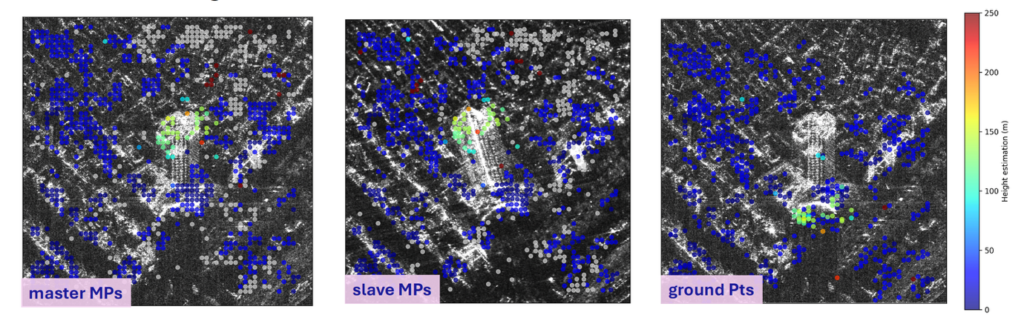
The presentation reported on a method for estimating building heights using X-band stereo SAR imagery. Corresponding points detected between two SAR images are converted into ground coordinates and matched against building footprint data from PLATEAU, Japan’s 3D city model provided by the Ministry of Land, Infrastructure, Transport and Tourism, to estimate the height of each building. Using real-world data, the presentation also included an accuracy evaluation comparing the estimated building heights against ground-truth measurements. The session drew a number of questions from research institutions and other organizations in Japan and abroad.
3.Overview of ESA FRINGE 2026
FRINGE is an international workshop on SAR interferometry (InSAR) organized by the European Space Agency (ESA), bringing together InSAR researchers, space agencies, and industry from around the world to discuss topics such as ground deformation analysis using Sentinel-1 data. The workshop is free to attend and features oral and poster sessions along with an exhibition area for InSAR-related companies.
- Name: ESA FRINGE 2026 (13th International Workshop on “Advances in the Science and Applications of SAR Interferometry”)
- Organizers: European Space Agency (ESA), Polish Geological Institute, Jagiellonian University
- Dates: June 15–19, 2026 (Mon–Fri)
- Venue: Jagiellonian University, Krakow, Poland
- Session: Poster Session I
- Presentation date: June 16, 2026
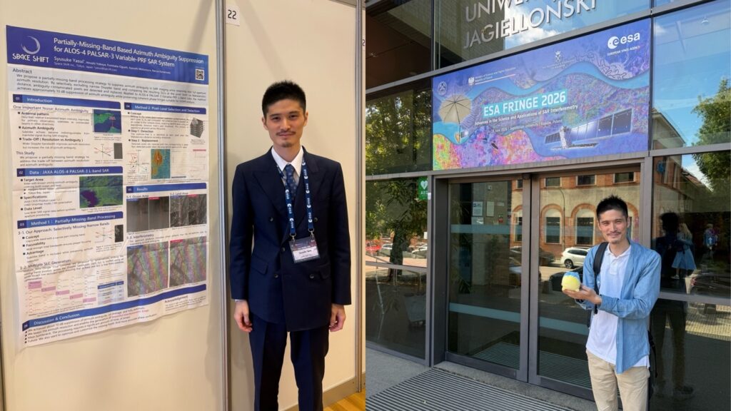
- Title: Partially-Missing-Band Based Azimuth Ambiguity Suppression for ALOS-4 PALSAR-3 Variable-PRF SAR
- Presenter: Yasui Syusuke (Space Shift)
- Authors: Hiroshi Yokoya, Fumitaka Ogushi, Kazushi Motomura, Naruo Kanemoto (Space Shift)
4.Presentation Details (ESA FRINGE 2026)
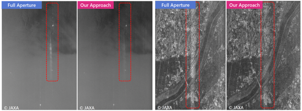
The presentation reported on a new signal processing method for suppressing “azimuth ambiguity,” a type of noise specific to SAR imagery, using data from PALSAR-3 aboard JAXA’s ALOS-4 (“DAICHI-4”) satellite. Azimuth ambiguity arises when radar echoes from unintended directions (sidelobes) mix with the main signal, and this effect tends to worsen as resolution is improved—creating a trade-off between the two. The proposed method combines multiple datasets, each with a different narrow portion of the frequency band intentionally excluded, to detect and replace noise-affected pixels while largely preserving image resolution. Validation using real data confirmed an average suppression of approximately 10 dB in azimuth ambiguity.
5.Going Forward
Space Shift is committed to solving social challenges through the power of satellite data and AI, and shares the results of its technology development in the SAR field with the domestic and international community through conferences and other venues. Going forward, we will continue to actively share our research findings beyond the conference setting.
Acknowledgments
This study utilized ALOS-4 data provided by the Japan Aerospace Exploration Agency (JAXA) under the collaborative research framework of the 4th Earth Observation Research Announcement (EORA). [https://earth.jaxa.jp/ja/research/cooperation/ra4/index.html]
■ For inquiries regarding this release
Space Shift Inc. (Attn: Yasui, Tutsumi, Mashima)
Inquiry Form: https://share.hsforms.com/1-fFRnQR2QwW3c-zOTCAanQ5m0z8
Email: pr@spcsft.com