[Press Release] Space Shift and WHERE Sign MOU to Develop and Provide Real Estate Solutions Utilizing Satellite Data
Aiming to Create New Business Opportunities and Value Through Participation in the “SateBiz” Co-Creation Program

Space Shift Inc. and WHERE Inc. (Headquarters: Bunkyo-ku, Tokyo; Representative Director: Akutsu Takeo; hereinafter “WHERE”) are pleased to announce that we have signed a Memorandum of Understanding (MOU) to collaborate on the development of real estate–related solutions utilizing satellite data.
In addition, through WHERE’s participation in SateBiz, the business co-creation program operated by Space Shift, the two companies will further accelerate their collaboration.
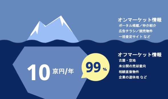
■ A Real Estate Market with Potential Valued at 1 Quadrillion Yen
WHERE recognizes that the real estate market contains a massive off-market segment valued at approximately 1 quadrillion yen, and develops and provides the real estate AI tool “WHERE,” which enables real estate businesses to connect directly with landowners.
WHERE believes that a “perspective from space” is essential to unlocking this vast latent market, and has previously conducted proof-of-concept (PoC) projects in collaboration with satellite data providers.
■ Combining Real Estate Information and Satellite Data for Higher-Order Insights
As WHERE advances the development of its real estate AI tool “WHERE,” it has increasingly recognized the diversification of needs among real estate operators. To address these needs, WHERE considers collaboration with satellite data companies possessing advanced technologies to be indispensable.
Meanwhile, Space Shift has cultivated advanced analytical technologies through the integration of a wide range of Earth observation data across diverse fields. Leveraging these capabilities, Space Shift provides high-level technologies in areas such as agriculture, urban dynamics monitoring, and disaster situation analysis.
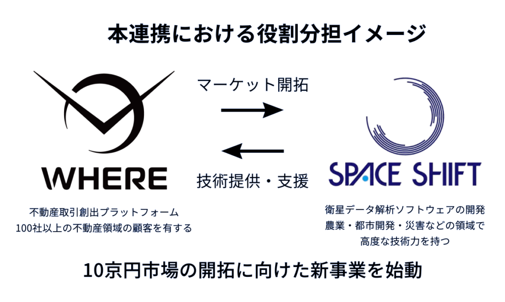
Through this collaboration between WHERE and Space Shift, it will become possible to deliver higher-order insights by combining real estate information with satellite data. This partnership aims to create new value across agriculture, urban development, and disaster-related domains, promote Space Transformation (SX) within the real estate industry, and ultimately target market opportunities on the scale of 1 quadrillion yen.
■ Participation in the Business Co-Creation Program “SateBiz”

SateBiz is a business co-creation program operated by Space Shift to promote the commercial utilization of satellite data. Approximately 70 companies from diverse sectors—including finance, real estate, agriculture, and GX—currently participate in the program.
By joining SateBiz, WHERE will deepen collaboration with participating companies and work toward the creation of new business opportunities and value.
■About WHERE Inc.
WHERE Inc. is a JAXA-originated startup with the vision of “Transforming the Earth’s real estate market from space.”
Founder and CEO Akutsu Takeo has previously founded and managed eight real estate–related companies. Seeking further challenges, he pursued research in space technology at the Graduate University for Advanced Studies (SOKENDAI) within the Institute of Space and Astronautical Science (ISAS), JAXA, leading to the development of the off-market exploration AI “WHERE” utilizing satellite data and AI.
Today, WHERE continues to expand collaborations across both public and private sectors.
・Company Name: WHERE Inc.
・ Location: 2-3-10 Mukōkō, Bunkyo-ku, Tokyo 113-0023, Japan
・Representative: Akutsu Takeo, Representative Director
・Business Activities:
Development and sales of the real estate AI tool “WHERE,” which connects with landowners
Manufacturing of space exploration vehicles
・Key Features:
Providing end-to-end support for real estate exploration, evaluation, management, and outreach using satellite data and AI
・Website: https://pntwhere.com/
■Contact Information
WHERE Inc.
Contacts: Fujii / Uchiyama
Email: pr@pntwhere.com
Space Shift Inc.
Contacts: Sato / Itoi
Email: sales@spcsft.com